The Columbia Gorge Cooperative Weed Management Area (CWMA) exists to foster and support collaborative weed management among public land managers and private landowners. Because weeds travel over the landscape and extend across multiple ownerships, collaboration and partnerships are essential for effective weed management. In addition, partnerships increase capacity, professional expertise, efficiency, and access to new and diverse funding sources. The intention of the CWMA is to provide guidance to local government and land managers on methods for utilizing available resources to control invasive weed problems regardless of political boundaries. The Columbia Gorge CWMA promotes weed education and outreach, weed inventory and prevention, and weed control activities.
Our Goals
Prevent the introduction and control the spread of harmful invasive plant species in the Columbia Gorge CWMA region by facilitating cooperative management among all willing land managers.
- Manage the Columbia Gorge CWMA through information sharing and relationship building.
- Inventory and assess weeds.
- Conduct outreach to raise awareness about weeds among the wider public.
- Sponsor effective and innovative weed control and native plant restoration projects.
Visit our Management Plan for a more comprehensive outline of our priorities.
Our Boundaries
In Washington, the Columbia Gorge CWMA includes lands in Clark County within the boundary of the Columbia River Gorge National Scenic Area; In Skamania, the CWMA extends northward along the Clark-Skamania County border to the USFS 90 Road, where it travels east to Curly Creek Road, along Curly Creek Road east to USFS 30 Road, then North to USFS 24 Road along the border of Indian Heaven Wild
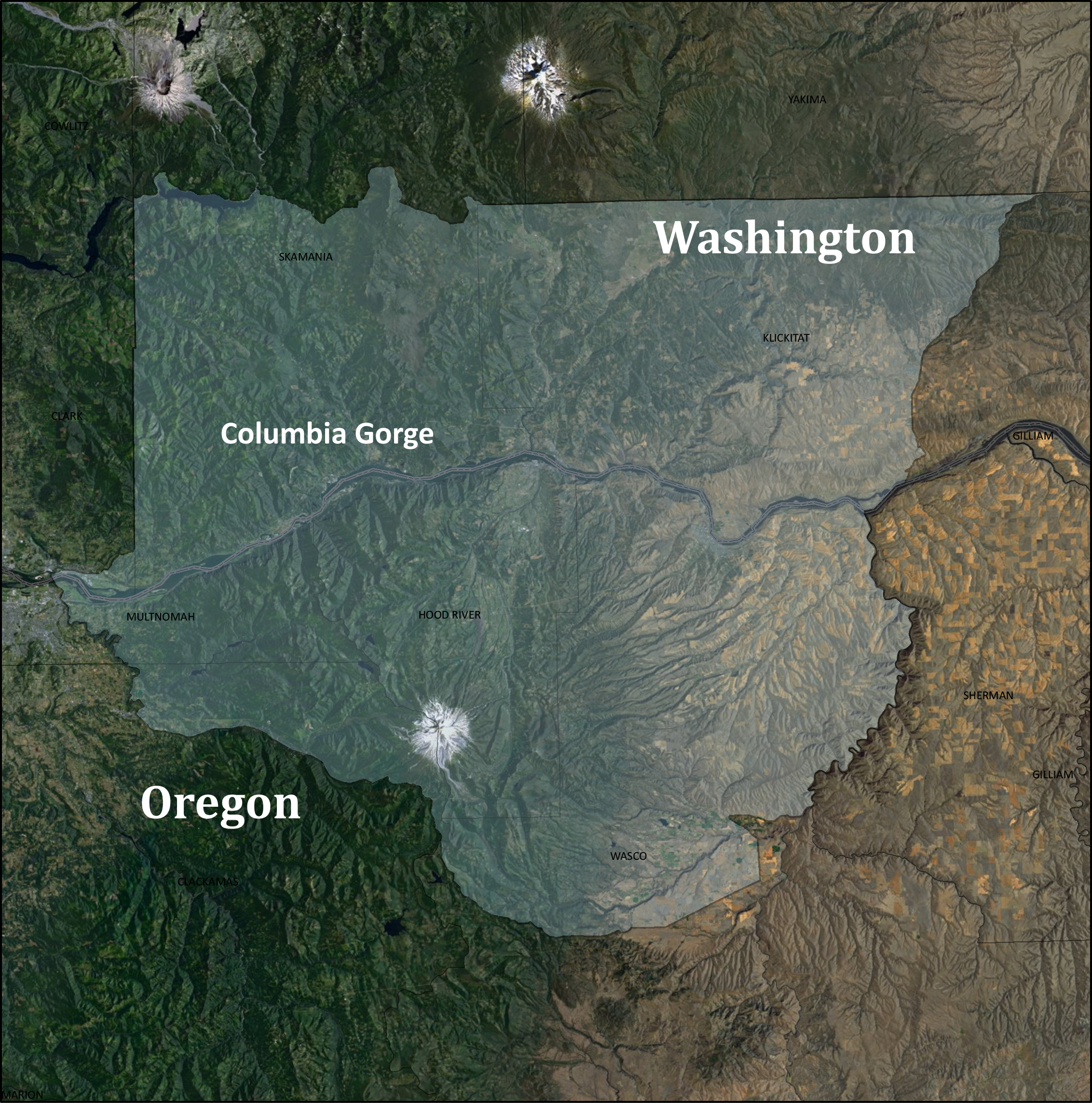
erness continuing on USFS 24 Road southeast to USFS Rd 8821, east onto the USFS 88 Road to the Klickitat County line. The border follows the northern Klickitat County line east to State Highway 97, then south where it meets the Columbia River. It includes the Wild and Scenic segments of the White Salmon and Klickitat rivers.
In Oregon, the Columbia Gorge CWMA extends eastward along the Columbia River from its confluence with the Sandy River to the Deschutes River, then upstream to its intersection with Highway 216, and then westward to Highway 26, continuing westward until the town of Sandy, then north on Ten Eyck Road to where it meets the Sandy River, then along the Sandy River to the confluence with the Columbia River.
Our Members
- Bureau of Land Management – Northwest Oregon District
- Cascade Pacific Resource Conservation & Development
- Clackamas Soil and Water Conservation District
- Clark County Public Works
- City of Portland – Portland Water Bureau
- Columbia Land Trust
- East Multnomah Soil and Water Conservation District
- Friends of the Columbia Gorge
- Hood River Soil and Water Conservation District
- Klickitat County Noxious Weed Control Board
- Oregon Department of Agriculture Noxious Weed Program
- Oregon State Parks
- Skamania County Noxious Weed Program
- Sandy River Watershed Council
- The Nature Conservancy
- Underwood Conservation District
- US Army Corps of Engineers
- USDA Forest Service – Mt. Hood National Forest
- USDA Natural Resources Conservation Service
- Wasco County Soil and Water Conservation District
- Washington Department of Natural Resources
- Washington Noxious Weed Control Board
*This is an actively growing list and will be revised as needed.
Become an official member of the Columbia Gorge CWMA!
The CWMA welcomes and encourages new partners to join our growing list of members! Visit our support page to learn how to become a CWMA member.
Questions? Email the CWMA Coordinator at columbiagorgecwma@gmail.com.
